 |
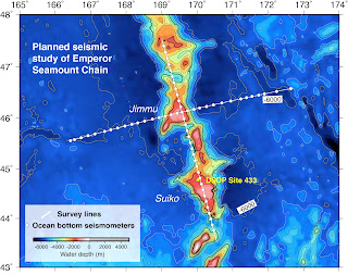
| Planned design of seismic study |
After cooling our heals for ~6 months on land, we are preparing to head out to sea again on the R/V
Marcus G. Langseth for the second phase of our project focused on the Hawaii-Emperor Seamount Chain. The first leg in September-October 2018 focused on the Hawaiian Islands, which are the newest additions to a ~6000-km-long chain of volcanos that continues northwest of Hawaii all the way up to Kamchatka. These volcanos get progressively older with distance away from Hawaii. Very little is known about the older Emperor Seamount Chain, particularly the geological structures below the seafloor. During the next 45 days, we will collect data to image the upper ~20-50 km of the earth beneath a ~60-million-year-old part of the Emperor Chain.
 |
Map of depth to seafloor showing the location of the
Hawaii-Emperor Seamount Chain |
One reason we know so little about the Emperor Seamounts is that they are a long way from anywhere, and so not easy to reach! Only a few academic ships have ever visited this region. During these expeditions, scientists collected rock samples or mapped the seafloor and shallow structure. No data have ever been collected that tell us about the geological structures deep below the seafloor. We were able to collect spectacular data with the
Langseth around Hawaii during the first phase of this project, so are very excited to see what similar data will reveal in this mysterious region. It will take us ~9 days to steam 2500 miles northwest from Honolulu to our field area, and I think it will be well worth the time and effort!
Donna Shillington, LDEO


Good Luck!
ReplyDelete