Scientific background

Why study the Hawaiian-Emperor Seamount Chain?

Bathymetric map of Hawaiian-Emperor Seamount Chain
The Hawaiian-Emperor Seamount Chain is the most well-known example on Earth of hotspot magmatism, where volcanoes form far from plate boundaries above hot regions in the underlying mantle. Many questions remain about the fundamental earth processes that create the volcanoes of the Hawaiian-Emperor chain and elsewhere, and how the enormous mass of these volcanos is supported by the oceanic plates below them. 

Understanding the way that the oceanic plate bends and deforms in response to the load of the island chain is also important for assessing hazards for the Hawaiian island region.  Faults form in the oceanic plate due to this bending; these faults generate earthquakes beneath and around Hawaii.


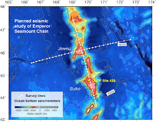
Seismic imaging of geology beneath the seafloor

Map of data collected during expedition around Hawaiian Islands
In order to determine the volume and composition of new crust formed from hot spot magmatism, how it varies along the island chain, and how the Pacific plate deforms in response to the weight of the volcanoes, we are collecting seismic data during two expeditions aboard the R/V Marcus G. LangsethThe first expedition is focused on the Hawaiian Island chain and is taking place Sept-October 2018.  The second expedition is focused on the Emperor seamount chain, and is scheduled for May-June 2019.  During these research cruises, sound waves generated by a controlled sound source towed behind the ship will be recorded on a 15-km-long cable filled with hydrophones (a seismic "streamer") and an array of ocean bottom seismometers deployed on the seafloor.  Combined, these data will allow us to image geology as deep as ~50 km below the seafloor.


Comments

Popular posts from this blog

The Emperors among us

Thank you thank you thank you

Calling OBS home before the weather