Posts

Showing posts from April, 2019

We are Golden Dragons now

Image
Crossing the 180 meridian.... We passed a couple of big milestones on our transit north today.   We are now closer to Adak, Alaska than Midway, Hawaii. We have thus passed the most remote point in our journey, when we were ~1300 km from land in any direction. The other big milestone is that we have sailed across the date line, and thus have entered the domain of the Golden Dragon and become rulers of the 180ยบ meridian .  Maria Tsekhmistrenko (Oxford)  designed awesome Golden Dragon certificates for everyone that will be signed and stamped by the Captain.  And w hen we get back to port in Kodiak, Alaska in 5 weeks, we can all rush down to the tattoo parlor and get tattoos of golden dragons. So that’s something to look forward to. Donna Shillington LDEO

Slow, steady progress....

Image
The yellow line shows the track of R/V Langseth as she heads northwest from Honolulu (yellow star) towards our field area (red lines). Each map shows our total progress at the end of that day. Only 1000 miles to go.....  Donna Shillington LDEO

The long trip north

Image
Preparing to lower a basket with GEOMAR OBS acoustics to 2000 m water depth for testing It is a long, LONG way from Honolulu to our study area in the Emperor Seamount Chain – 2500 miles (4000 km). It’s about the distance of a coast-to-coast drive across the United States.    Ships travel much slower than cars – we have been averaging 9 nautical miles per hour, which is 10.5 mph. So it will take us at least 9 days of steaming around the clock to reach the field area.   The science party and science technical staff have been using the time required for this long journey to test and prep equipment that will be used during the study and to share our science with each other through talks, lectures and discussions.   Valeria describes her research on the Nazca Ridge (while bracing herself from ship motion!) During the transit, the ocean bottom seismic teams from GEOMAR and WHOI have been testing each component of the equipment. On Thursday, they ...

Back to sea...

Image
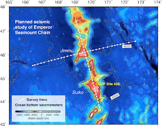
Planned design of seismic study After cooling our heals for ~6 months on land, we are preparing to head out to sea again on the R/V Marcus G. Langseth for the second phase of our project focused on the Hawaii-Emperor Seamount Chain.  The first leg in September-October 2018 focused on the Hawaiian Islands, which are the newest additions to a ~6000-km-long chain of volcanos that continues northwest of Hawaii all the way up to Kamchatka.  These volcanos get progressively older with distance away from Hawaii.  Very little is known about the older Emperor Seamount Chain, particularly the geological structures below the seafloor.  During the next 45 days, we will collect data to image the upper ~20-50 km of the earth beneath a ~60-million-year-old part of the Emperor Chain. Map of depth to seafloor showing the location of the Hawaii-Emperor Seamount Chain One reason we know so little about the Emperor Seamounts is that they are a long way from anywhere, and so n...