Posts

In the fog...

Image
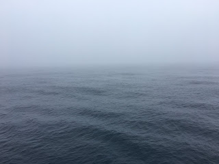
For the last few days, we have had calm seas and been ensconced in a thick fog much of the time. Right now, this doesn't pose any problems for our science operations - we are cruising along and acquiring seismic reflection data, which can illuminate the subsurface just fine, fog or no fog.  But the fog is starting to make everyone on the ship a little crazy!   Normally one is treated to expansive ocean views at sea, but instead we get to see this: The horizon is out there somewhere... Perhaps even more disconcerting, the ship sounds a special fog horn at regular intervals to alert other ships that we have limited maneuverability since we are towing equipment. It consists of one long horn followed by two shorter ones. It is very loud.  Everyone on the ship will tell you that this horn must be located right outside their  cabin. We can live with it for now, but soon we will transition back to OBS work. When its time to pick them up, it would be super helpfu...
Half-way through

Image
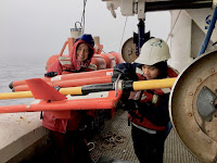
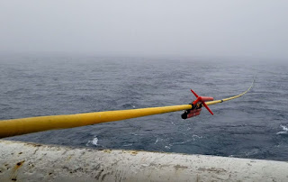
Our expedition is moving along steadily. We have now completed collecting both wide-angle and seismic reflection data for our first profile. The Langseth is cruising toward our second line of survey which is about two days away (13hrs from now). In the past few days, we have had some very exciting experience with seismic acquisition including an opportunity to see how a hydrophone streamer was deployed into the water, 15 km of it.   The streamer is a carrier of hydrophones which we use to record the sound wave signals generated by our airguns that were reflected back to us from the subsurface. We have a set of hydrophones place every 12.5 m along the streamer. As watchers on the earliest shift of the day we got to spend a field day on the streamer deck and joined in with the crew to learn about streamer deployment and all of the advanced technologies that come with it. Putting out a 15-km-long line of hydrophones into the ocean is no trivial job. We were tasked with assem...

The first seismic reflection line!

Image
The streamer disappearing into the misty horizon. We already finished the first seismic reflection line! Deploying the streamer was a lot of work, but definitely worth it. 15 kilometers of hydrophones will allow us to identify more deeper structures, like the moho. Mei releasing an XBT into the ocean. While collecting the data, we had to keep an eye on the streamer tension, the multibeam bathymetry recording - like we always do - and we had to release some XBT's, which are instruments used to measure the water column temperature. This is important information for the bathymetry data and operation of equipment, but also for the seismic oceanography studies that Will has been working on. As scientists, we spend a lot of time in the comfy main lab (cleaning the multibeam files haha), so it's a refreshing experience to go out to release the XBT's. It's super cold outside and my shift goes from 2am to 10 am, so this time - as well as when we were deploying the O...

In and out of the water

Image
Chris snags WHOI OBS under Tim's watchful eye. It’s been a busy week! After we finished deploying 28 ocean bottom seismometers on the seafloor along a ~500-km-long profile across Jimmu Seamount in the Emperor Seamount Chain, we steamed back down the line creating seismic sources with the specialized seismic source array of the R/V Langseth .   We then retrieved all of the OBS. Sound waves from the seismic source array travel up to ~20 miles below the seafloor, and then bend back towards the surface. The returning sound waves are recorded by the ocean bottom seismometers, which are very sensitive and detect very small vibrations at the seafloor. We can model the paths of sound waves through the earth and the time it takes them to travel along those paths to image geological structures deep below the Emperor Seamount Chain, which is one of the main objectives of our study. While we were creating sound sources along the line, Valeria and Luan did some tests of ho...

Oh, the wind and waves...

Image
Deployment of GEOMAR OBS during calmer conditions  Our study area did not exactly roll out the welcome mat for us when we arrived a few days ago.   The first part of our program involves deploying ocean bottom seismometers (OBS) along a ~300-mile-long profile across the Emperor Seamount Chain. As we have endeavored to do this during our first few days, we’ve faced winds up to ~40 kts and waves up to ~28 feet, forcing us to pause science operations for hours at a time to wait for better weather.   Even when we were able to work, conditions were sometimes tough.   The ship pitches and rolls in the waves, and water washes over the starboard deck from which we stage and deploy OBS.     These are not ideal conditions to lift a ~500-pound piece of scientific equipment over the side of the ship and gently release it into the ocean!   Several folks got drenched by cold waves coming over the side during these operations. When the ship tak...

Finally some action!

Image
Luan preparing for XBT deployment. After a long, nine-day transit without much activity, we finally approached our survey site. By the time I started my shift at 2:00 am on May 2nd, we had already begun collecting bathymetric data from the multibeam echosounders. It was nice to record a bathymetric structure that is about 1000 m high and 7000 m across. For us watchers, such a feature is always more interesting than looking at a flat seabed for hours during a shift. Most excitingly, at 7:25 am we deployed the first OBS into the water. Right afterward, I got a chance to personally deploy a XBT into the water. This is to record the temperature and salinity of the seawater and help constrain the water density which in turn controls the velocity of sound waves in water. We need this information on a regular basis to calibrate the seafloor depth recorded by the multibeam. I The XBT was supposed to sink to 1.6 km depth and then to be retrieved for its reading. Anyway, we have 30 O...