Knowledge sharing on the high seas
Our first week at sea could often be described by the expression “Hurry up and wait!” When we are on station (the term used to describe being at the location where we deploy OBSs) everyone is working at full capacity. Whether it is technicians and students on deck preparing and launching the OBSs or the watch standers in the lab managing instruments and keeping careful records, everyone has a job to do and we all take our jobs seriously. However, the ocean is a rather large place, and the time it takes to go from one station to another can stretch. One might imagine all of us scientists running up to the top deck to get a marvelous Hawaiian suntan during these quiet periods, but the truth of what we are up to is even more exciting.
We are having science meetings to discuss the aims and motivations of our study.
 |
| Tony explains seismic profile acquired by R/V Conrad in 1982 |
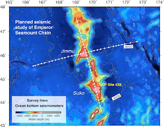
Less than a week into our journey and we have had two science meetings, lead by principle investigators (PIs) Donna Shillington and Tony Watts. Scientists are voracious learners, and these meetings are ideal times for us graduate students to better understand the scientific objectives and motivating factors behind our expedition. Today’s discussion centered on the interesting gravity anomaly surrounding the Hawaiian Islands.
Gravity measurements are a powerful tool used by geophysicists to elucidate the structure of the earth below the surface. Aboard our ship we have instruments that can measure the strength of gravitational attraction, and we know the strength of the attraction changes based on the density of the features far below our feet. In simplest terms, regions underlain by dense features have high gravity, regions underlain by less dense features have lower gravity.
The Hawaiian Island gravity anomaly shows that the beautiful islands where so many people vacation every year are a dense geologic feature that are heavy enough to bend the surrounding oceanic plate. That bend from the load of the islands creates a gravity low surrounding the island chain. More broadly the region has the gravity signature of what is thought to be low-density melt pooling beneath the lithosphere, extending for hundreds of kilometers around the islands – this is likely the signature of the hotspot that created this island chain.
These measurements give us a peek into what is going on deep beneath the surface of the earth, but more data is required to get the full picture of the structure of the earth in this fascinating region. Our expedition will add a plethora of marine seismic data to that picture, furthering scientific understanding.
Bridgit Boulahanis, LDEO

Comments
Post a Comment